'Playground of the People?' Mapping Racial Covenants in 20th Century Minneapolis

In the summer of 2014, veteran property researcher Penny Petersen led a group of Augsburg College undergraduates on a history quest at the Hennepin County Government Center. Under Petersen’s tutelage, the student interns for the Historyapolis Project searched at the Registrar and Recorder’s Office for critical lines of text that could illuminate the hidden history of race in Minneapolis during the twentieth century. They were looking for racially restrictive deeds—or racial covenants—which barred people who were not white from owning property. These kinds of deeds were the most powerful instrument of segregation in the urban north during the twentieth century.
The students were quickly overwhelmed. The text they were seeking could only be found by scrolling through millions of property records on microfilm reels. But Petersen was inspired. And she decided that she would do what no one had ever done. She would track when and where restrictive deeds were embedded in the urban landscape of Minneapolis.
This was the beginning of the Mapping Prejudice project, which has brought Petersen together with scholars and students from Augsburg College and the University of Minnesota to unearth and map racially restrictive property deeds in Minneapolis.
During the first half of the twentieth century, real estate developers and public officials used covenants to build what amounted to a hidden system of American apartheid. Unlike segregated bathrooms or watering fountains, racial covenants were largely hidden from the public eye in bound volumes at the county. But in Minneapolis and elsewhere, these property contracts were the bulwarks of white supremacy.
Mapping Prejudice began in earnest when Peterson sampled approximately 20,000 Minneapolis properties and found over 5,000 deeds with racially restrictive language. The project has since identified an additional 25,000 restrictive deeds located throughout Hennepin County. Once these records are processed, the Minneapolis covenants will be added to Peterson’s initial sample. The resulting database will serve as the basis for the first-ever comprehensive visualization of racial covenants for an American city.
The deeds tell a sobering story of racial exclusion. In tandem with redlining—a banking practice that made it impossible to get loans for properties in racially mixed neighborhoods—racially restrictive deeds in Minneapolis shut African Americans out of property ownership. In the mid-twentieth century, homeownership was an emblem of American citizenship as well as what scholars have called the “greatest mass-based opportunity for wealth accumulation in American history.”[i]
The work started with the Historyapolis Project at Augsburg College, which is committed to working with students to document some of the more challenging aspects of the past in Minneapolis. But after visiting the property records office with Petersen in 2014, project director Kirsten Delegard realized she lacked the expertise necessary for this kind of systematic inventory.
Fortunately, Petersen was fascinated by the challenges of this research. In 2015, she began assembling a database that would grow to include several thousand restrictive deeds. Delegard then enlisted Kevin Ehrman-Solberg, a graduate student in the GIS program at the University of Minnesota, who works at the school’s Borchert Map Library. Ehrman-Solberg began to map the deeds located by Petersen and soon became the project manager, masterminding the effort to build the databases necessary for this visualization. With the support of University of Minnesota librarian Ryan Mattke, Delegard, Ehrman-Solberg, and Peterson made the Borchert Library their base of operations. They decided to work together to document the spread of racial covenants across Minneapolis.
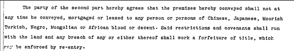
Racial covenants began in California in the 1880s[ii]. By the early twentieth century, they had spread to the urban north. The earliest deed restriction Mapping Prejudice has identified was recorded in 1910 in South Minneapolis, when Henry and Leonora Scott sold a property on 35th Avenue South to Nels Anderson. The deed conveyed in that transaction contained what would become a common restriction, stipulating that the “premises shall not at any time be conveyed, mortgaged or leased to any person or persons of Chinese, Japanese, Moorish, Turkish, Negro, Mongolian or African blood or descent.” Scott became the first president of the Seven Oaks Corporation, a real estate developer that inserted this same language into thousands of deeds across the city.
Scholars like Kenneth Jackson and Tom Sugrue have documented how deeds like these had the enthusiastic support of both public officials and private industry across the United States during the twentieth century.[iii] Real estate developers created them. The Federal Housing Authority endorsed them. Bankers and property owners embraced them as a way to protect property values. In 1948, The Supreme Court declared them unenforceable after a sustained legal campaign by the NAACP. They were banned in Minnesota in 1953. But they remained in use across the country until 1968, when the Fair Housing Act made them explicitly illegal.
This legal history has been told. But no one has ever made a complete map of these restrictions, thanks to the difficulties of extracting this kind of information from the historic records. Petersen demonstrated how to find these kinds of deeds. But a comprehensive survey and visualization would have been impossible without the help of computers.
In 2016, Hennepin County gave Mapping Prejudice access to its database of digitized property deeds. This database contained every warranty deed abstract recorded between 1900 and 1960, for a total of over 1.4 million records. This dataset allowed the team to build an innovative new protocol for mapping covenants. The deeds are scanned for racial language using Optical Character Recognition (OCR) software. Flagged deeds are fed into a crowd-sourcing research platform called Zooniverse. Students and community volunteers use this platform to answer a series of questions about the flagged deed images. This crowd-sourced data is then exported into a spreadsheet and mapped using ArcGIS. This computer-assisted research is building on the work done by Petersen to unearth the structural racism embedded in the physical landscape of Minneapolis.
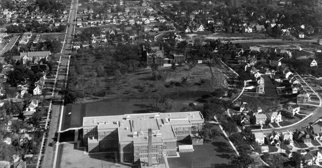
The maps that have emerged from this initial research are prompting questions that extend beyond the realm of housing. Neighborhoods fronting parklands exhibit the highest concentration of covenants we have found thus far. While Minneapolis parks were never explicitly segregated, the sheer number of racial covenants surrounding them indicates that access was anything but equal.
These early patterns call into question some of the central assumptions of civic life in Minneapolis, highlighting the need for more nuanced understandings of how race has shaped public space in the city.
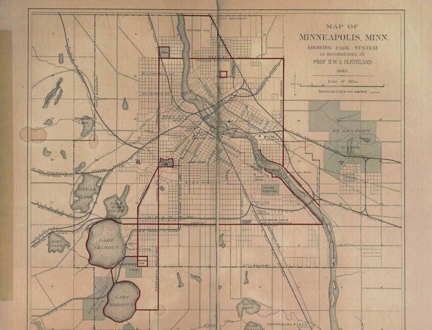
Minneapolitans love their parks, which have been named the nation’s best by the Trust for Public Land for several years in a row. From its beginning in 1883, the Minneapolis Park Board sought to acquire all the land bordering streams, lakes, and rivers. This strategy created the nationally renowned Grand Rounds, the 60 miles of public trails and parkways that meander along Minnehaha Creek to link the Mississippi River gorge to the Chain of Lakes. This carefully planned green space transformed Mill City into the City of Lakes in the early twentieth century.
Residents like to brag that their waterfront is the playground of the people. But the initial visualizations generated by Mapping Prejudice show that some of the most desirable green spaces in the city were ringed by residential districts that barred people of color from taking up residence. The result was an invisible racial cordon around the city’s urban commons.

This map illustrates how racial covenants blanketed neighborhoods adjoining some of the most spectacular holdings of the Minneapolis Park system. Several neighborhoods around Minnehaha Creek, Lake Nokomis, and Diamond Lake were almost completely restricted. The empty space you see on this map likely contained additional covenants.

By the mid-twentieth century, much of the Grand Rounds was encircled by neighborhoods that excluded people who were not white. This pattern of exclusion demonstrates the need for new work that re-examines how access to Minneapolis parks and waterways was shaped by race.
This inquiry speaks to a growing body of research on the legacy of racism in American green spaces.[iv] Over the last decade, scholars have brought new attention to this topic, illuminating how seemingly race-neutral parks and green spaces were racialized through interlocking practices. “Whites only” signs were just one of the mechanisms that made urban green space unwelcoming to African Americans.
This scholarship bolsters the campaign by grassroots activists associated with the local NAACPand Parks and Power who are pushing the Minneapolis Park Board to incorporate racial equity into its strategic planning and administrative processes. The Trust for Public Land, which has given Minneapolis such high marks for its parks, only considers park acreage, per capital spending, and the numbers of residents who live within a half-mile of a park. But the quality of American parks, journalist Brentin Mock concludes, after surveying this literature, can no longer be assessed without a consideration of race.
The visualizations that are emerging from the Mapping Prejudice project provide critical historical context for this ongoing dialogue. The project seeks to catalyze community conversations about past injustices that can chart productive ways to address current disparities.
To learn more about racial covenants, watch “Jim Crow of the North.”
Read Kirsten Delegard’s piece on how racial covenants took a firm hold in Minneapolis, “Emanuel Cohen and the Battle Against Anti-Semitism in Minneapolis.”
This work is licensed under a Creative Commons Attribution-NonCommercial 4.0 International License (CC BY-NC 4.0).
Footnotes
[i] Melvin L. Oliver and Thomas M. Shapiro, Black Wealth/White Wealth: A New Perspective on Racial Inequality (New York: Routledge, 1995), 18.
[ii] M. Jones-Correa, “The Origins and Diffusion of Racial Restrictive Covenants,” Political Science Quarterly, 2000 Winter, 115(4), 541–568.
[iii] Kenneth Jackson, Crabgrass Frontier: The Suburbanization of the United States (New York: Oxford University Press, 1985): 208–209.
Thomas J. Sugrue, The Origins of the Urban Crisis: Race and Inequality in Postwar Detroit (Princeton: Princeton University Press, 2005, Classic edition): 44–46.
[iv] See, for example, Carolyn Finney, Black Faces, White Spaces: Reimagining the Relationship of African Americans to the Great Outdoors (Chapel Hill: The University of North Carolina Press, 2014).
Recommended Citation
Delegard, Kirsten and Kevin Ehrman-Solberg. 2017. “‘Playground of the People’? Mapping Racial Covenants in Twentieth-century Minneapolis.” Open Rivers: Rethinking The Mississippi, no 6. http://editions.lib.umn.edu/openrivers/article/mapping-racial-covenants-in-twentieth-century-minneapolis/.
DOI: https://doi.org/10.24926/2471190X.2820
Download PDF of “Playground of the People”? Mapping Racial Covenants in Twentieth-century Minneapolis by Kirsten Delegard and Kevin Ehrman-Solberg.
This story is made possible by the Arts and Cultural Heritage Fund and the citizens of Minnesota.